Patagonia. It’s a place that means much to many, from a voyage of discovery for Magellan or economic opportunities for early 19th-century European settlers to adventure or luxury for modern travelers; and of course, the native cultures and environmental bounty that both stand in danger of disappearing completely.
Patagonia is, not quite literally, the southern edge of anywhere. Yet with all this potential, and all the beauty, most visitors to Chilean Patagonia pop in for a week to visit the most famous national park before heading back home. While no touristic visit will ever be truly ‘complete’, here’s your travel guide to Chilean Patagonia that will at least help you to dig in a bit deeper and explore more of this incredible region.
Table of Contents
Your Travel Guide to Chilean Patagonia

Torres Del Paine National Park
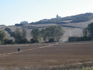
This is the thousand-pound gorilla of Chilean Patagonia: the absolute center of tourism in the region. Over 140,000 visitors entered the park in January of 2016. The thing is: you should totally go. It’s a beautiful natural environment made easy by dedicated transport, lodging, and access options. You can pop into Pudeto for a day, hike the ‘W’ for four, or hit the ‘O’ and ‘Q’ in a week. There are luxury hotels, backcountry refuges, and campsites all along the way. In short, this is just about the easiest way to do long-distance hiking… pretty much anywhere in the Americas.

There are countless travel blogs detailing the ins and outs, or if you’re already in gateway town Puerto Natales hit up the Base Camp Pub’s fantastic 3 o’clock talk for everything you need to know.
Bernardo O’Higgins National Park
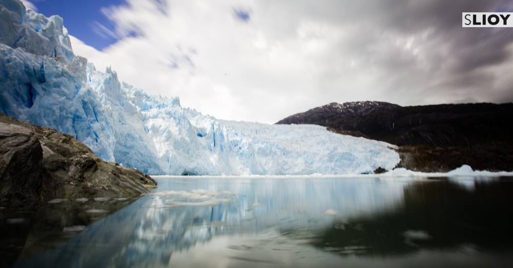
If Torres Del Paine is the star of the tourism show, Bernardo O’Higgins National Park is the ‘Best Kept Secret’ just next door. The park, itself around 13,000 square miles (that’s more than 35,000 square km), encompasses most of the Southern Patagonian Ice Field. A 6,500 sq mi (16,800 sq km) chunk of glaciers, ice, snow, lakes, and fjords carving its way through the Chilean and Argentinian Andes. The catch? It’s also super remote. There are no roads between Southern and Northern Chilean Patagonia, and the unbroken expanse of the Southern Patagonian Ice Field is the reason why. The only way to visit is by boat, whether the “budget” $600 ferry between Puerto Natales and Puerto Montt or the luxury Cruceiros Skorpios Patagonia fjord cruises that depart from the same cities. It’s all very expensive, out of the way, with limited departures and high competition for space…. but these are also incredible landscapes. If you’re going to make one splurge while in Patagonia, one of these boat trips through the Campo del Hielo Sur isn’t a bad place to do it.
[The linked post above, on my MonkBoughtLunch travel blog, was the product of a partnership with Skorpios.]
Magallanes Province:
Mating Penguins, the Southern Cross, and the Land of Fire
Largely regarded as a transit point, the city of Punta Arenas also makes a decent base for a number of short trips throughout Magallanes province. The most well-known, pictured above, is the ferry ride to Isla Magdalena and the 120,000 Magellanic Penguins that show up each summer for a lil’ bit of penguin lovin’. Less famous but just as well worth the visit are the volcanic landscapes of Pali Aike National Park, the 5-day hike to the edge of continental America at Cabo Froward, or the land of fire across the strait in Tierra del Fuego (itself home to a number of long-distance hikes, cultural relics, and stunning landscapes). Most visitors to the south of Chilean Patagonia (including to Torres Del Paine) will fly through Punta Arenas at some point, so there’s little reason not to linger in the region and explore further afield.

Puerto Montt: Gateway to the Lake District
If Punta Arenas has the reputation of a skippable pass-through, northern city Puerto Montt has a repute that’s downright sinister. “Don’t walk with your valuables out! Stay in at night! Guard your money and passport!” I found, instead, a nice-enough city that was also a fantastic base from which to explore Northern Patagonia. Lazy little lake town Puerto Varas is a half hour ride away, the “Chilean Yosemite” in the Cochomo Valley is two hours south, and from there the Carretera Austral highway stretches onwards. Will you want to spend your whole trip in Puerto Montt? Probably not. But if you’re of a mind to visit any of the numerous national parks nearby, count on passing through here for a few days to relax and restock.
(Incidentally, if airport security confiscates all your camping gas, you can pick that up here as well!)

The Northern Parks:
Fjords, Volcanoes, Glaciers and Lakes
Huge national parks, private conservation reserves, ancient glaciers, and recently erupted volcanoes. As the Carretera Austral winds its way from Puerto Montt to the south through Patagonia, it passes by a bit of it all. The place that catches the most international headlines is Parque Pumalin, and indeed it’s a great place to visit as an independent traveler given that the most accessible Pumalin South and Amarillo sections hug the Carretera Austral about eight hours south of Puerto Montt. Hidden waterfalls (pictured above), smoking volcanoes, and well-marked and -conserved trails through lush temperate rain forest. More remote, access to the trails and hot springs of Pumalin North is by boat only – but reportedly worth the effort if you can make it happen.
Just north of Pumalin is the Hornopiren National Park‘s remote trailheads and underused trail system, bordering Pumalin to the south is the Corcovado National Park‘s expanse covering more than eighty lakes and the country’s first marine sanctuary, while further on the Patagonia Park‘ trails are considered among the best in the region. At these or any of the other national parks and private reserves in Northern Patagonia, there are plenty of trails to hike, glaciers to ogle, and ice-cold lakes to swim through for as long as you can stand.

The Southern Carretera Austral
The Carretera Austral dead ends at the 600-person town of Villa O’Higgins – a 35-hour drive south of Puerto Montt on a road that was only completed in 2000. Along the way the glacier and lakes at Yelcho (above) and San Rafael, the appropriately named Northern Ice Field, and more island offshore than you could reasonably hope to explore. This is either an epic road trip or hardcore hitchhiking territory, but the payoff is travel through a remote region stuffed with nearly-empty trails and a true sense of adventure – a far cry from the Torres Del Paine hike that starts and ends so many trips!

Travel Guide to Chilean Patagonia
Planning an even longer trip to Chile?
Make sure to see our 7 Reasons to Visit Northern Chile as well!